Technical Services
GIS
Our experienced and knowledgeable team of GIS professionals are here for all your geospatial needs. The department provides an integral component to our project planning, design and construction. Our services can satisfy a broad range of needs from varying entities and across multiple industries utilizing the latest industry-leading ESRI ArcGIS Software.
Percheron's multi-discipline project viewer, GRID, allows our GIS team to work seamlessly with each of our service lines to provide clients with the most complete view of their projects.

GIS Data Management & Integration
Enterprise GIS Data Management
- Versioning
- Multi-User Editing
- Data QA/QC
- Enterprise Views enabling 15-minute sync from GRID Database
- Data backups
GRID Database/GRID Webmap Integration
- Seamless integration into our proprietary GRID database
- Near real time updates between database/GIS applications
Data Conversion Services
- Raster to vector conversion
- Analog to digital (paper maps to digital data)
- CAD/GIS formats & KMZ conversion
GIS Analysis
Routing & Siting Analysis
- Routing Analysis utilizing Pivvot
- Project Summary and Detailed Reporting
- Siting Analysis utilizing ArcGIS Pro
Feasibility Study & Route Selection
- Feasibility study route creation using proprietary and Pivvot routing applications
- SME experience in route planning
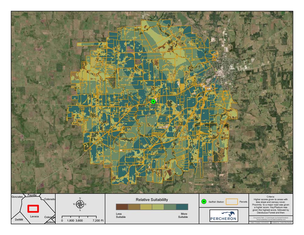
Siting & AOI Support
- Siting analysis using Pivvot and various GIS techniques (raster analysis, high-grade maps, weighted overlay maps, etc.)
HCA (High-Consequence Area) Analysis & Material Estimation
- Identifying class requirements within +/- 20% for material estimates
Advanced GIS Analysis
- Raster Analysis, distrubance modelging, weighed value analysis, proximity analysis, etc.
Webmap Applications
Custom Webmap Applications & Support (GRID)
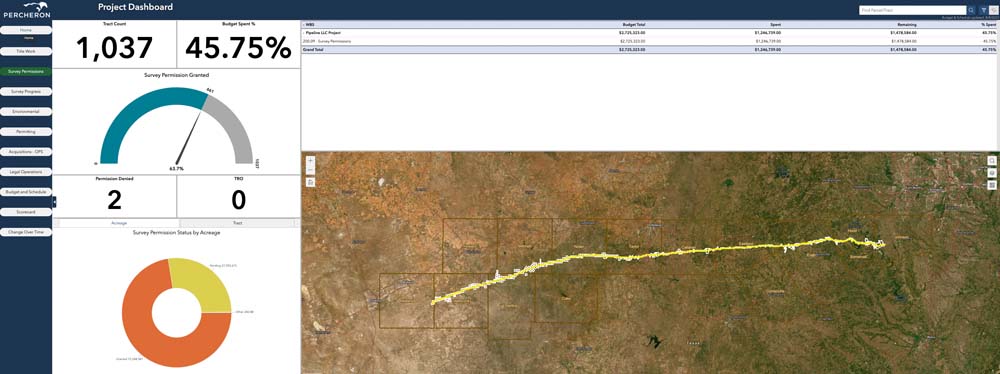
- Project Dashboard featuring schedule and budget tracking
- Client/Project Landing Page
- Google Earth Street View Wedget
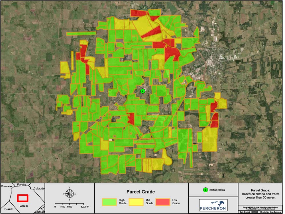
- Project Scorecard with dynamic status parcel shading
- Alignment Sheet Widget
- Construction Inspection Widget
- Construction As-Built Tracking Widget
- Construction Reporting Dashboard
- Custom Print Templates
ArcGIS Portal & AGOL
- Routing Analysis utilizing Pivvot
- Project Summary and Detailed Reporting
- Siting Analysis utilizing ArcGIS Pro
ArcGIS Field Maps
- Data collection utilizing ArcGIS Field Maps
- Integration of Construction Widget to create visual representations of progress utlizing stationing of tasks performed
- Custom Schema setup
Mapping & Visualization
Due Diligence Mapping
- Plotting and mapping agreements (Lease/Easement/SS)
Technical Mapping
- Engineering route maps
- Environmental maps (CR/NR Figures)
- Preliminary exhibits
- Permit crossing maps
- Map books, etc.
Data Conversion Services
- Raster to vector conversion
- Analog to digital (paper maps to digital data)
- CAD/GIS formats & KMZ conversion
Reporting & Anlaytics
Pivvot Reporting
- Route Summary Report
- Detailed Routing Report
- Crossing and Impact Report
- Permitting Punch List Report (Federal Level Reporting)
- Constraint Reports - Solar Siting/Electric Substations
Reporting Dashboards
- Custom experience builder applications for reporting project metrics
RDR (Route Deviation Request) Widget
- Track reroutes on large capital projects
- Email notifications for approvals
- Custom setup of user permissions for approbals by discipline with automatic date/user tracking
- Automatic numbering/sequencing of RDR's for tracking with unique ID
Client & Platform Integration
Third-Party & Client Platform Integration
- Dynamic customization and integration with most third-party and client platforms
GRID Data/Application Subscriptions
GRID Data/Application Subscriptions
- Pivvot Routing Software including Regrid parcel data
- ESRI Applications (Pro extensions/ArcGIS Server/AGOL)
- Hart Energy Existing Transmission and Well Data (Continental US)
Client Testimonies
The Percheron GIS team is talented, professional, efficient, and very detailed oriented. The GIS team understands project development and the multi-faceted GIS layers required to get a project construction ready. They coordinate across disciplines to create a comprehensive GIS data set cohesively integrating acquisition, land rights, access, road use, survey, engineering, crossings, and environmental survey data.
Project Development
Utility Developer