Survey
Successful surveying projects depend on accuracy, consistency, and reliable results. Percheron is one of the few names in the field that has the capabilities to make it happen. Our employees are licensed experts who not only represent a vast amount of industry knowledge but they also work to understand your specific business and project needs.
From right-of-way acquisition surveys to complex plant surveys, we do it all to ensure your project demands are consistently met. And because we employ extensive quality assurance processes and utilize the industry’s leading software and technology, we’re able to deliver superior results—even when deadlines are tight.
At Percheron, we utilize the latest technology, equipment, and software to help deliver superior results. Where others might cut corners, we continually invest in the most current resources available to the industry—such as Trimble RTK Global Positioning Systems and unmanned aerial systems. In addition, our technicians are experienced in the preparation of drawings in AutoCAD™, Skyline™ Sheet Generating software, and GIS. Our field and office staff are also able to prepare digital terrain models and right-of-way maps on difficult schedules utilizing our automated software.
Percheron professionals also excel in managing the acquisition of high-resolution airborne laser mapping (LIDAR – Light Detection and Ranging) and aerial photogrammetric mapping for large projects.
Our Story
38 YEARS SERVING OUR CLIENTS
Today, Percheron is committed to providing excellent service to our clients through our fully integrated suite of Engineering, Survey, Environmental, Land, and Title services. Percheron’s integrated services model allows us to eliminate duplication and increase productivity through accountability, so you can measure the success of your project for what matters the most...on-time and under budget.
![]()
WHAT’S IN A NAME?
When Percheron Acquisitions was established in 2007, the founding parties spent a lot of time stressing the importance of choosing the right name. Trent Oglesby, CEO of Percheron LLC, gathered a group of employees together to discuss name ideas, and Percheron was suggested.
Trent said, “After doing a little research on Percheron horses, I found that Percherons were utilized in building the infrastructure of early America, which worked well with our service offerings. I also liked the fact that these horses were known for their strength, dependability, and hard work, characteristics that fit with the company we were creating. It’s different and a great conversation starter. Even if people don’t know what a Percheron is, they usually never forget the name.”
WHAT IS A PERCHERON?
The Percheron is a large draft horse that is very popular in the United States and Canada. It is known for its even temperament and good manners. They are dependable animals that are willing to work. Percherons range in height from 15 to 19 hands high (60-76”), and most are between 16-2 (66”) and 17-3 (71”) hands high. They can weigh up to 2600 pounds, with an average of around 1900.
The Percheron has a very pleasing disposition: proud, alert, intelligent, and willing worker. The Percheron is very versatile. They are readily adapted to varying climates and conditions, have the strength to pull heavy loads, and the graceful style to pull a fine carriage. Percherons can be ridden, and some have been known to make fine jumpers.
Two Percheron horses pulling together cannot pull twice as much as one. They can actually pull three times as much. The two horses that can each pull 8,000 pounds alone can pull 24,000 pounds working together.
That kind of teamwork has served as a foundation for Percheron for the last 38 years and will continue to be a driving force in providing our clients with the best service possible.
Survey Technology
By Utilizing Leading-Edge Software, Equipment, and Technologies—Percheron Helps Ensure Accuracy, Efficiency, and Greater Project Precision.
Our survey team utilizes several industry-standard equipment platforms, software suites, and tools to execute projects, including Autodesk AEC Design Suite, BlueSky, Global Mapper, Forefront Design Specialist - Plat Mapper, etc. We also use several in-house customized tools to help automate workflows; these tools cover a wide spectrum of survey services and deliverables.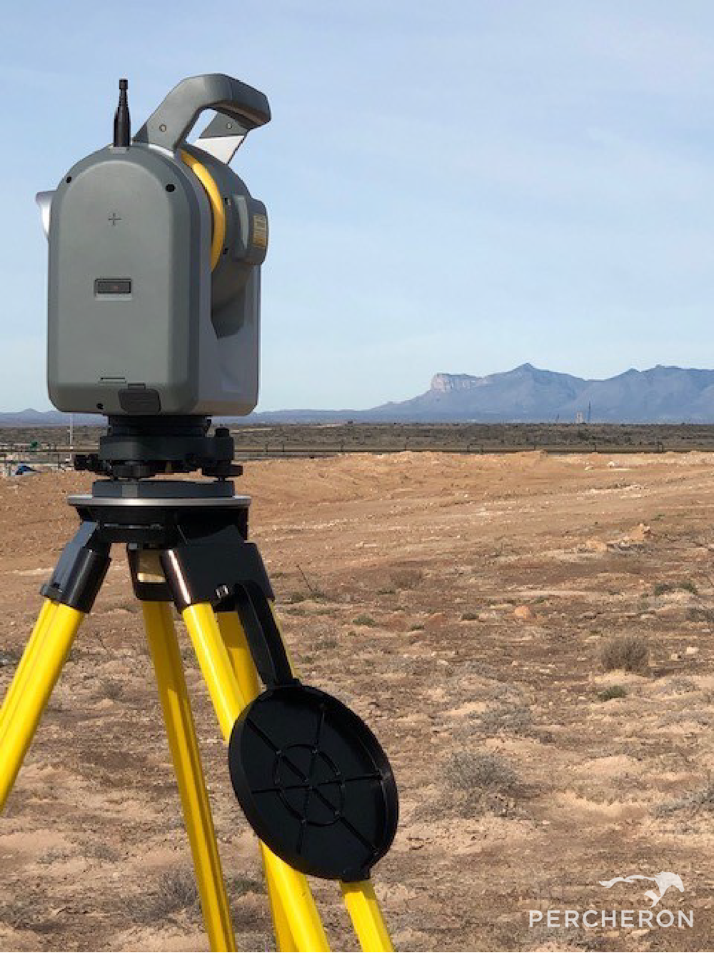
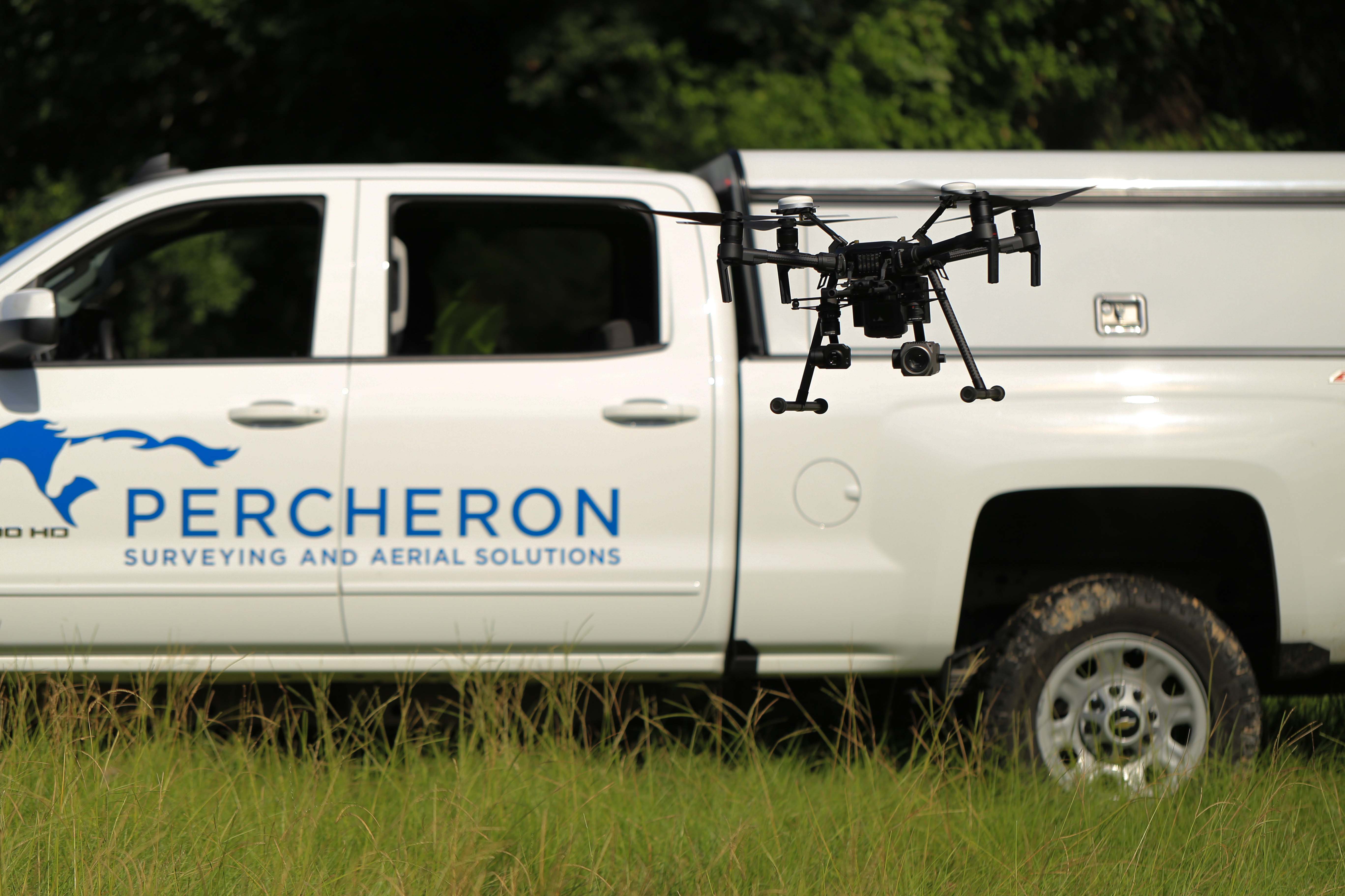
- Field Crews: Percheron field crews are outfitted with state-of-the-art equipment, including Trimble model R10-12 receivers, Radios Detection RD8100 pipeline locators, Reflectorless total stations, and all other relevant equipment to provide the full range of field services. We have several terrestrial scanning capable crews outfitted with the latest laser scanners and hybrid camera scanner setups and dedicated UAV crews to capture all aerial survey and inspection needs.
- UAS and Scanning: Percheron's Aerial Imagery team utilizes industry-standard software suites depending on the application, including Pix4D Capture/Cloud//Mapper/Survey/and Inspect, Trimble Business Center, Bentley MicroStation and Terrasolid, Global Mapper LiDAR, Trimble RealWorks. Percheron uses a wide range of sUAS platforms and manufacturers based on client needs, including quad and hex copters as well as traditional fix-wing UAVs and VTOLs. We also use Riegl and Phoenix aerial LiDAR sensors, full-frame Sony RGB cameras, 200x zoom inspection cameras, FLIR thermal cameras, and SlantRange and MicaSense multispectral, etc.
- Mapping team: Our mapping team utilizes a variety of programs to ensure the highest quality deliverables to each of our clients.
- Trimble Business Center, a Trimble field to finish Survey CAD software, helps deliver high-accuracy GNSS data.
- AutoCAD Civil3D, an Autodesk software that allows 2D & 3D design. This allows us to produce construction drawings, property plats, permits, and site-specific drawings.
- Skyline, a Bluesky software that creates accurate alignments sheets, with a Microsoft Access Database to accelerate workflow and makes changes faster.
- DASH a Bluesky software paired with a data management tool. This software includes QA/QC tools that ensure the reliability and verification of the data being collected. Orbital's Survey Module is a Bluesky software that streamlines pipeline survey management by helping to maintain quality, budget, and schedule without creating extra work for field crews. You can immediately evaluate imported data and track trends to know exactly what the survey teams are doing in the field. It allows you to set time and delivery expectations, track and assess data, and keep communication streamlined in real time.
- Plat Mapper a Forefront Design Specialist software that allows multiple plats to be cut at once for faster plat production.
- Global Mapper is a BlueMarble Software with abundant GIS tools for data creation, editing, and analysis.
- ArcMap, an Esri software with abundant GIS tools for data creation, editing, and analysis, allows the creation of quality drawing deliverables.
Renewable Energy
Your Partner in Your Pursuit of Clean Energy Solutions
Renewable energy projects are complex and stretched over lengthy time horizons. That’s why you need an experienced team to ensure all of your engineering, right of way, environmental, surveying, title, and GIS needs are completed in a detailed and timely manner. Whether it be traditional wind and solar renewable energy generation and associated battery storage, to green hydrogen or electrofuel project development, Percheron’s team can help guide your project from concept to completion through our integrated service offerings:
- Project Planning and Design
- Landowner Outreach
- Mapping
- Instrument Negotiation and Execution
- Surveying
- Environmental Assessments
- Data Management
- Engineering
- Mineral Title Research
- Surface Use Waivers
- UAS Surveying
- Title Insurance liaison
- Project Development and Execution Consulting
- O&M Support
- Immediate Pre-Closing Support
- Greenfielding & Brownfielding Support
- Permitting & Regulatory Support
- Easement Access & Crossing Permits
- Feasibility Studies
Looking for a partner on your next project? Let us show you how Percheron can partner with you on your Renewable development pipeline. Contact us today
Do you need help planning, executing, and managing your next project? Percheron can help!
Think Integrated
Percheron, the nations leading professional services firm, was formed out of the merger of three leading land services companies: Mason Dixon Energy, OGM Land, and Percheron in June 2012. We offer specialized expertise in engineering, land surveying, environmental, acquisitions, and title research, providing a cohesive, integrated solution for projects of any size. For some companies, the ability to organize and execute projects on a nationwide scale is just an ambition. But Percheron offers more than a promise – our record of sustained excellence and client retention proves where we’ve been and where our partnerships can go together. Headquartered in Katy, TX, our team of professionals is committed to the use of cutting-edge technology, exceptional client service, and timely and efficient project management, coast-to-coast. ![]()
So when you Think Percheron, Think Integrated!
Welcome to Percheron
We are a team of professionals who have significant experience executing any size project in nearly every state in the Lower 48. We choose to recognize our relationship with our clients as a "Partnership". Partners expect honesty, transparency, accuracy, consistency, and reliability. Our employees believe in these values, making us proud to be a part of the Percheron team.
Efficiency and accountability to achieve success motivate us. That's why we use an integrated service model. Every project requires concept development, knowing the ownership of land, who owns the surface and mineral rights, acquiring those rights, surveying the land, providing design, drawings, and schematic, and understanding the environmental impacts.
By implementing this integrated approach, we:
- Align schedules between disciplines
- Use consistent reporting software and invoices
- Do the work one time and share between groups
This is who we are. We do it well, and we do it right. So when you Think Percheron, Think Integrated!