Land Administration
Percheron has a fully staffed Land Administration Department (“LAD”) that works from our centralized office in Katy, Texas. Our LAD group works in tandem with our right of way agents, title abstractors, surveyors, and GIS to generate documents, send mass mailouts, manage data, and record documents in the applicable county records.
We set high expectations for our team to provide quality deliverables. LAD can control the work product and supervise the work even if the document specialist is in the field. Our teams’ refined processes ensure consistency and efficiency for your projects. In addition, we customize those processes to serve each client’s specific needs and expectations for project success. Our cutting-edge processes are established as best industry practices for our office, Percheron, and clients.
Percheron’s Land Administration Department has streamlined the document and check request process. With the aid of IT, LAD created an app for requesting documents to be generated and request checks processed through the department, along with any other agent request.
Renewable Natural Gas
With a full suite of integrated services, our team can provide comprehensive project management from initial feasibility study, through right of way & environmental permit acquisition, detail design, and construction. Our team has over 17,000 miles of linear experience that provide you with expertise no matter how large and complex the project becomes. Our service include:
Feasibility Study:
- Project Budgeting
- Material Lists, Specifications and Bid Documents
- Construction Job Showing, Bid Evaluation
- Preliminary Routing
- Line List & Permit Matrix
- TIC Estimate
- Environmental Desktop
- Analysis
- Stakeholder Engagement Planning
- Wetland Delineations
- Endangered Species Field Survey
- Archaeological Field Survey and Report
- Pipeline Detail Design
- Facility Design
ROW & Environmental Permit Acquisition, Detail Design
- Constructibility Report
- Preliminary Pipeline Design
- Preliminary Title & LTCs
- Survey Permission & Support
- Deed Plots, Boundary
- Analysis & Centerline Survey
- Negotiations
- Plat, Permit, Alignment Sheet, Construction Detail Production
- Environmental Permitting
Construction
- Pre-Construction Staking
- Aerial Inspections
- As-Built Alignment Sheets & Data Delivery
- Environmental Consultation & Construction Support
- Job Book Description
- Final File & Data Transfers
GIS
Our experienced and knowledgeable team of GIS professionals are here for all your geospatial needs. The department provides an integral component to our project planning, design and construction. Our services can satisfy a broad range of needs from varying entities and across multiple industries utilizing the latest industry-leading ESRI ArcGIS Software.
Webmap Applications:
- GRID – Utilizing the ESRI ArcGIS Online Webmap applications in combination with our database and reporting tools we can provide a one-stop-shop for viewing, tracking, and reporting on your project.
- ArcGIS Collector – Custom schema for your specific project in a file Geodatabase that can be built real-time in the field leveraging the collector application you can track project progress as it’s collected and easily convert the data into GIS deliverables.
- Google Earth – A often popular file format, KMZ/KML files are used in the field that GIS can ingest to create customized versions to display embedded images, custom attribution, and symbology to make your project shine.
Data Management:
- Percheron GIS can handle your data management needs with decades of combined experience. From an Enterprise-style multi-user GIS editable in AGOL with a recorded username/date/time logs in a hosted feature service to our customizable database application, we have the tools to suit your project. ArcGIS Online collaboration groups for data sharing cut down on emails and data silos. Data layers from the Webmap can be extracted and exported directly with a creator-level license.
- From initial tract load in CityVerse to get your project up and running in lightning-fast time, to tract numbering, reroute processing, title, survey spatial updates, and change tracking, we have you covered.
- Data QA/QC using topology rules to identify and eliminate gaps and overlaps.
- CityVerse database allows for tracking of multiple acquisition types on one property to avoid redundancy and countless hours wasted updating the same information repeatedly.
Cartography:
- Static maps – PDF Maps, Plotter maps, Permit Mapbooks, Map Series (Mapbooks) for linear projects, we can make a customized map to suit your project's specific needs.
- Preliminary Exhibits – aka Landowner Sketches – Percheron GIS can generate these customized PDF maps to get in front of your landowner for survey and acquisition in a fraction of the time utilizing data-driven pages to generate 100’s of exhibits in short order.
GIS Analysis
- Disturbance modeling – utilizing a lidar dataset or DEM and converting to a vector dataset to extract slope data and applying to create an easement along the road at a predefined distance that fluctuates based on grade.
- Siting
- Routing
- Proximity analysis – (distance from line to point), intersections, unions, dissolves, buffers, spatial joins, per tract lengths & acreages, etc.
Route Selection:
- Utilizing industry-leading 3rd party Pivvot software, Percheron GIS conducts route analysis and generates route options. Using 100’s of public and private data layers for weighted analysis, we find the most suitable route to minimize costly reroutes.
Site Suitability Analysis:
- Utilizing industry-leading Pivvot software Percheron GIS can conduct site placement review for you based upon factors such as:
- Slope (i.e. less than 10% grade)
- Oil/Gas set back
- Wetlands
- Proximity to Roads
- Floodplain
- Airports
- Powerlines
- Land Use/Land Cover
Automation:
- Utilizing python to look for the most efficient workflows
- Data-driven pages for Mapbook and preliminary exhibit creation
- Python scripts to link the tabular data from the CityVerse database to the GRID Webmap App
Data Conversion
- Taking PDF maps and converting them into vector datasets using georeferencing.
- Converting raster into a vector to run advanced analysis using ArcGIS geoprocessing tools for datasets such as slope, land use, land cover, DEM.
- Converting between different data types – KML, KMZ, Shapefile, File Geodatabase Feature classes, DWG, DGN, etc.
Digitization
- Plot metes and bounds of tract or easements from a deed or conveyance into projected vector polygons with requested schema.
- Digitize based on static PDF maps into vector datasets.
Our Story
38 YEARS SERVING OUR CLIENTS
Today, Percheron is committed to providing excellent service to our clients through our fully integrated suite of Engineering, Survey, Environmental, Land, and Title services. Percheron’s integrated services model allows us to eliminate duplication and increase productivity through accountability, so you can measure the success of your project for what matters the most...on-time and under budget.
![]()
WHAT’S IN A NAME?
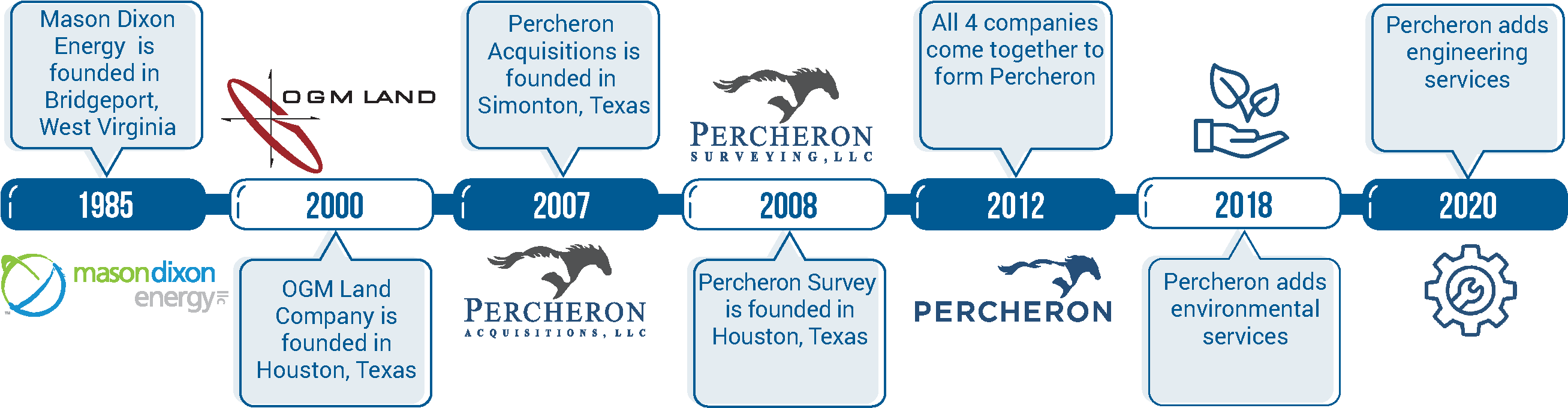
When Percheron Acquisitions was established in 2007, the founding parties spent a lot of time stressing the importance of choosing the right name. Trent Oglesby, CEO of Percheron LLC, gathered a group of employees together to discuss name ideas, and Percheron was suggested.
Trent said, “After doing a little research on Percheron horses, I found that Percherons were utilized in building the infrastructure of early America, which worked well with our service offerings. I also liked the fact that these horses were known for their strength, dependability, and hard work, characteristics that fit with the company we were creating. It’s different and a great conversation starter. Even if people don’t know what a Percheron is, they usually never forget the name.”
WHAT IS A PERCHERON?
The Percheron is a large draft horse that is very popular in the United States and Canada. It is known for its even temperament and good manners. They are dependable animals that are willing to work. Percherons range in height from 15 to 19 hands high (60-76”), and most are between 16-2 (66”) and 17-3 (71”) hands high. They can weigh up to 2600 pounds, with an average of around 1900.
The Percheron has a very pleasing disposition: proud, alert, intelligent, and willing worker. The Percheron is very versatile. They are readily adapted to varying climates and conditions, have the strength to pull heavy loads, and the graceful style to pull a fine carriage. Percherons can be ridden, and some have been known to make fine jumpers.
Two Percheron horses pulling together cannot pull twice as much as one. They can actually pull three times as much. The two horses that can each pull 8,000 pounds alone can pull 24,000 pounds working together.
That kind of teamwork has served as a foundation for Percheron for the last 38 years and will continue to be a driving force in providing our clients with the best service possible.
Environmental
Our team of qualified specialists provides environmental services and in-depth knowledge of federal, state, and local level environmental regulations for energy and infrastructure projects from the conceptual design and planning stages through construction, operations, and closeout. We work with our clients to ensure solutions that will address your project’s environmental and permitting needs. Our experience gives us the knowledge and foresight to expedite and streamline the environmental permitting process to ensure the commencement of construction of your project on time and on budget.
Land
When it comes to land management, you need service that meets your standards, your needs, and your project timeline—even in the most complex cases. That’s why Percheron only offers the most experienced professionals to handle all projects across the country. On every assignment, our dedicated experts are able to leverage a complete range of fully integrated resources to keep you on track. It’s the kind of attention to detail that keeps delays, surprises and worries out of the land management process.
Pipeline
From front-end engineering and design (FEED) through permitting, detail design and acquisitions, through complete project execution, our team can help with any phase of your pipeline project and ensure your assets are managed properly. With over 20,000 miles of linear experience across the country on some of the most complex projects, Percheron is the right partner for every phase of your project. Our experience spans beyond your traditional pipeline projects to include facilities, carbon capture sequestration, and transporting hydrogen. As the energy world continues to evolve, our team is there to take lead.
At Percheron, we believe that working as a fully integrated team is the key to success. From engineering project development to in-house title agents and field survey crews, to our senior right-of-way agents and environmental permitting specialists, all of our team members stand united with one common goal – ensuring that your project succeeds. We eliminate duplication and increase productivity through accountability so you can measure the success of your project for what matters the most...on-time and under budget. We are confident that our ability to staff any project of any size nationwide coupled with our processes and proven success, makes Percheron the only choice for your pipeline project needs.
Think Integrated
Percheron, the nations leading professional services firm, was formed out of the merger of three leading land services companies: Mason Dixon Energy, OGM Land, and Percheron in June 2012. We offer specialized expertise in engineering, land surveying, environmental, acquisitions, and title research, providing a cohesive, integrated solution for projects of any size. For some companies, the ability to organize and execute projects on a nationwide scale is just an ambition. But Percheron offers more than a promise – our record of sustained excellence and client retention proves where we’ve been and where our partnerships can go together. Headquartered in Katy, TX, our team of professionals is committed to the use of cutting-edge technology, exceptional client service, and timely and efficient project management, coast-to-coast. ![]()
So when you Think Percheron, Think Integrated!
Welcome to Percheron
We are a team of professionals who have significant experience executing any size project in nearly every state in the Lower 48. We choose to recognize our relationship with our clients as a "Partnership". Partners expect honesty, transparency, accuracy, consistency, and reliability. Our employees believe in these values, making us proud to be a part of the Percheron team.
Efficiency and accountability to achieve success motivate us. That's why we use an integrated service model. Every project requires concept development, knowing the ownership of land, who owns the surface and mineral rights, acquiring those rights, surveying the land, providing design, drawings, and schematic, and understanding the environmental impacts.
By implementing this integrated approach, we:
- Align schedules between disciplines
- Use consistent reporting software and invoices
- Do the work one time and share between groups
This is who we are. We do it well, and we do it right. So when you Think Percheron, Think Integrated!