PROJECT SEQUENCING REVAMPED
The "do loop".
As a project manager, designer, or team member, do you find yourself in a continuous “do loop” – running in never-ending circles – chasing environmental constraints that cause the redesign of projects, permitting delays or worse, increase in costs? What if you could significantly reduce this repetitive cycle?

To date myself, when I started in the environmental consulting industry, we completed our environmental surveys using a USGS 7.5 Minute Topographic Map, a line drawn on this map, and a compass to navigate our way to collect the necessary environmental data to successfully design and permit a project. We also had the aid of survey stakes every 200 feet or so to direct us, but the “pungee sticks” created by the surveyors in wooded areas certainly created safety hazards. If we needed to survey out from a centerline, we had to use a measuring tape to find the extent of the survey corridor. This was not only cumbersome but also increased the risk of trespassing and data points were less than precise. This archaic survey method certainly did not provide fast turnaround data to the project designers. If constraints were identified, the project had to be redesigned, surveyors sent back out, environmental crews resurveyed the new route, and hopefully the “do loop” would cease.
What if I said there was a better way?
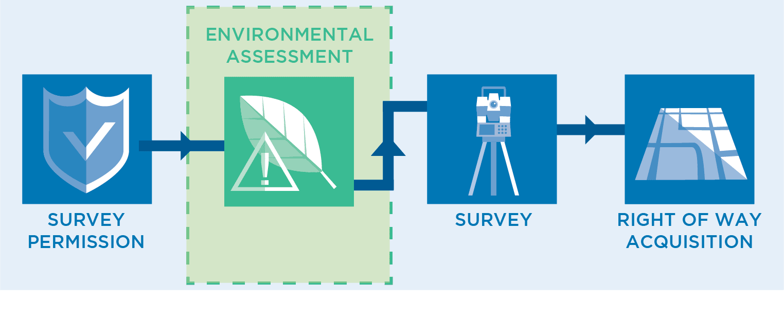
There certainly is but it is not just about the advancements in technology. Certainly, the use of submeter, or better, GPS, online viewing systems, and email have increased the accuracy and speed at which data can be collected and transmitted to design and other project staff. But I believe the best way to reduce the “do loop” caused by environmental constraints is to simply change the sequence of the project. I suggest putting the environmental teams out ahead of survey immediately after obtaining survey permissions from the right-of-way group.

While this approach – of which I am a proponent – may raise some eyebrows, it is the key to minimizing project delays. I’ll explain.
Right-of-way agents, surveyors, and environmental teams are inextricably linked, making coordination critical. Knowing the potential pitfalls of a project early can expedite the design, permitting, and ultimate construction of a project. If the pitfalls are known early, then a project can be redesigned to avoid a specific issue, maybe avoiding permitting altogether, or at a minimum, helping to develop a permitting strategy that meets the project objectives. To detect pitfalls early in the project, environmental crews can operate with submeter GPS and a buffered KMZ file ahead of the survey crew to generate nearly real-time reporting of data to the project team.
In today’s environment (pun intended), environmental permits are generally the long lead task on a project schedule, apart from pipe and other equipment orders. The strategy of initiating environmental surveys – i.e. wetlands, threatened and endangered species, and cultural resources surveys early will reduce costs through aiding design, expediting permitting or allowing avoidance or the ability to mitigate the issue early.

Let’s be honest, environmental survey and permitting costs are generally a rounding error of the proposed overall costs of major projects. Environmental survey costs are less than civil survey costs so reducing the amount of reroutes that are created from the environmental do loops can save significant dollars.
The value of a truly effective environmental consultant is the ability to secure environmental permits and the authorization for construction in a timely manner. If a project is not flowing product or providing public convenience, it is not providing value to the company or the community. Keep your project moving and stop the "do loop". Get ahead of potential project setbacks by sending the environmental team out before the survey crew.
