
FDI Creative
Engineering
Percheron’s Engineering staff is comprised of fully seasoned professionals, licensed in 36 states, with experience throughout the lower 48 States and Alaska. While primarily focused on midstream design, the Engineering team has extensive experience in designing and installing electrical systems and infrastructure. Our present capabilities range from switchyard design to cross-country transmission networks. Working in conjunction with our environmental, survey, land, and title business units, our fully integrated service offering increases our value to clients through enhanced process efficiencies and innovative project technologies. The high level of professionalism the engineering business unit provides will meet/exceed the same level of exceptional service you’ve grown to expect.
GIS
Our experienced and knowledgeable team of GIS professionals are here for all your geospatial needs. The department provides an integral component to our project planning, design and construction. Our services can satisfy a broad range of needs from varying entities and across multiple industries utilizing the latest industry-leading ESRI ArcGIS Software.
Webmap Applications:
- GRID – Utilizing the ESRI ArcGIS Online Webmap applications in combination with our database and reporting tools we can provide a one-stop-shop for viewing, tracking, and reporting on your project.
- ArcGIS Collector – Custom schema for your specific project in a file Geodatabase that can be built real-time in the field leveraging the collector application you can track project progress as it’s collected and easily convert the data into GIS deliverables.
- Google Earth – A often popular file format, KMZ/KML files are used in the field that GIS can ingest to create customized versions to display embedded images, custom attribution, and symbology to make your project shine.
Data Management:
- Percheron GIS can handle your data management needs with decades of combined experience. From an Enterprise-style multi-user GIS editable in AGOL with a recorded username/date/time logs in a hosted feature service to our customizable database application, we have the tools to suit your project. ArcGIS Online collaboration groups for data sharing cut down on emails and data silos. Data layers from the Webmap can be extracted and exported directly with a creator-level license.
- From initial tract load in CityVerse to get your project up and running in lightning-fast time, to tract numbering, reroute processing, title, survey spatial updates, and change tracking, we have you covered.
- Data QA/QC using topology rules to identify and eliminate gaps and overlaps.
- CityVerse database allows for tracking of multiple acquisition types on one property to avoid redundancy and countless hours wasted updating the same information repeatedly.
Cartography:
- Static maps – PDF Maps, Plotter maps, Permit Mapbooks, Map Series (Mapbooks) for linear projects, we can make a customized map to suit your project's specific needs.
- Preliminary Exhibits – aka Landowner Sketches – Percheron GIS can generate these customized PDF maps to get in front of your landowner for survey and acquisition in a fraction of the time utilizing data-driven pages to generate 100’s of exhibits in short order.
GIS Analysis
- Disturbance modeling – utilizing a lidar dataset or DEM and converting to a vector dataset to extract slope data and applying to create an easement along the road at a predefined distance that fluctuates based on grade.
- Siting
- Routing
- Proximity analysis – (distance from line to point), intersections, unions, dissolves, buffers, spatial joins, per tract lengths & acreages, etc.
Route Selection:
- Utilizing industry-leading 3rd party Pivvot software, Percheron GIS conducts route analysis and generates route options. Using 100’s of public and private data layers for weighted analysis, we find the most suitable route to minimize costly reroutes.
Site Suitability Analysis:
- Utilizing industry-leading Pivvot software Percheron GIS can conduct site placement review for you based upon factors such as:
- Slope (i.e. less than 10% grade)
- Oil/Gas set back
- Wetlands
- Proximity to Roads
- Floodplain
- Airports
- Powerlines
- Land Use/Land Cover
Automation:
- Utilizing python to look for the most efficient workflows
- Data-driven pages for Mapbook and preliminary exhibit creation
- Python scripts to link the tabular data from the CityVerse database to the GRID Webmap App
Data Conversion
- Taking PDF maps and converting them into vector datasets using georeferencing.
- Converting raster into a vector to run advanced analysis using ArcGIS geoprocessing tools for datasets such as slope, land use, land cover, DEM.
- Converting between different data types – KML, KMZ, Shapefile, File Geodatabase Feature classes, DWG, DGN, etc.
Digitization
- Plot metes and bounds of tract or easements from a deed or conveyance into projected vector polygons with requested schema.
- Digitize based on static PDF maps into vector datasets.
- land management
- upstream
- midstream
- resource
- land
- land development
- feasibility studies
- site selection
- due diligence
- lease
- acquisition
- amendment
- right of way
- mineral
- testing
- permit
- mapping
- administration support
- file review
- surface
- relocation assistance
- operations support
- maintenance
- survey permissions
- survey support
- pipeline
- oil and gas
- electric transmission
- utilities
- exploration
- production
- highway
- roads
- transportation
- transmission
- distribution
- public sector
- private sector
- engineering partner
Our Story
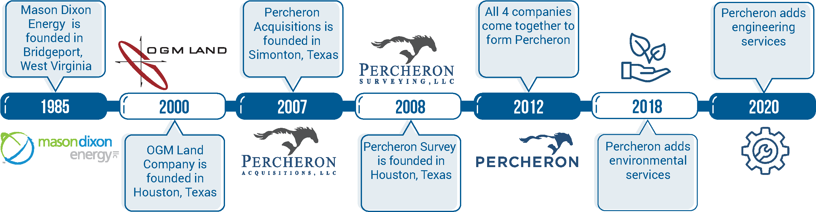
38 YEARS SERVING OUR CLIENTS
Today, Percheron is committed to providing excellent service to our clients through our fully integrated suite of Engineering, Survey, Environmental, Land, and Title services. Percheron’s integrated services model allows us to eliminate duplication and increase productivity through accountability, so you can measure the success of your project for what matters the most...on-time and under budget.
![]()
WHAT’S IN A NAME?
When Percheron Acquisitions was established in 2007, the founding parties spent a lot of time stressing the importance of choosing the right name. Trent Oglesby, CEO of Percheron LLC, gathered a group of employees together to discuss name ideas, and Percheron was suggested.
Trent said, “After doing a little research on Percheron horses, I found that Percherons were utilized in building the infrastructure of early America, which worked well with our service offerings. I also liked the fact that these horses were known for their strength, dependability, and hard work, characteristics that fit with the company we were creating. It’s different and a great conversation starter. Even if people don’t know what a Percheron is, they usually never forget the name.”
WHAT IS A PERCHERON?
The Percheron is a large draft horse that is very popular in the United States and Canada. It is known for its even temperament and good manners. They are dependable animals that are willing to work. Percherons range in height from 15 to 19 hands high (60-76”), and most are between 16-2 (66”) and 17-3 (71”) hands high. They can weigh up to 2600 pounds, with an average of around 1900.
The Percheron has a very pleasing disposition: proud, alert, intelligent, and willing worker. The Percheron is very versatile. They are readily adapted to varying climates and conditions, have the strength to pull heavy loads, and the graceful style to pull a fine carriage. Percherons can be ridden, and some have been known to make fine jumpers.
Two Percheron horses pulling together cannot pull twice as much as one. They can actually pull three times as much. The two horses that can each pull 8,000 pounds alone can pull 24,000 pounds working together.
That kind of teamwork has served as a foundation for Percheron for the last 38 years and will continue to be a driving force in providing our clients with the best service possible.
Gwen Longo

Gwen Longo is a Program Manager for Percheron, LLC. She has 9 years of experience working in the energy industry, previously serving as Regional Manager, Northeast. After receiving her Bachelor's degree from Slippery Rock University of Pennsylvania, Gwen began her career as a GIS Technician and was promoted into project management in 2016. She has been involved in the right of way process from beginning to end; from initial routing design with engineers, building property boundaries with title, document generation and review, easement acquisitions, landowner and attorney negotiations, construction support, reclamation, and project closeout. Gwen is an active member of the International Right of Way Association (IRWA).
Liborio Salinas

Liborio "Libo" A. Salinas, Jr. is a Managing Director for Percheron, LLC, with 14 years of experience in the energy industry.
Libo began his career as a Petroleum Landman, reviewing title for mineral ownership, preparing leases, providing due diligence, preparing right of way agreements, and completing lease packets. He joined Percheron in 2011 as a Petroleum Landman in the Eagle Ford Shales. He began working as a Title Agent and Right of Way Agent and was promoted to an in-house Title position, first as a reviewer and subsequently as Title Supervisor. In 2017, Libo took the position of Regional Manager, South Central - Field Services, overseeing multiple major midstream pipeline projects, as well as managing an extensive integrity program for one of the largest all-natural-gas distribution companies in the region.
Libo served on Percheron's internal safety committee, helping to develop and implement various employee safety initiatives, including wristbands to promote safety awareness and Percheron 360°, encouraging employees to conduct a 360° walk around their vehicles before entering the vehicle.
He is an active member of the American Association of Professional Landmen (AAPL) and International Right of Way Association (IRWA) and holds a Texas Real Estate License.
Jeremiah O'Dean

Jeremiah O’Dean, PS, LS is a professional land surveyor with over 16 years of survey experience in oil & gas, transportation, power generation, subdivision and land development for public and private entities. He has experience in the oil/gas and power generation market sectors and is extremely knowledgeable with various types of surveying equipment and field surveying procedures, survey data adjustments, courthouse research, topographic surveys, ALTA/ACSM Land title surveys, Boundary Retracements, preliminary/as-built pipeline surveys, and various CAD & GIS mapping applications. Jeremiah is a Registered Professional Land Surveyor in CA, FL, GA, ID, KY, LA, MD, MS, NC, ND, NM, NY, OK, PA, SC, SD, TN, UT, VA, WI, WV, and WY.
Patrick Curlin

Patrick Curlin is Mapping Lead - Survey for Percheron with over 26 years of experience in pipeline route design and mapping. He is experienced in coordination, personnel, for both small, fast-paced, multi-state projects and large, multi-year, long linear projects. He serves as mapping lead for select projects throughout the nation. In addition, he has extensive technical skills in different CAD programs. Patrick is Blue Sky certified Level II.
Michael Muallem

Michael Muallem is Mapping Manager - Survey for Percheron with over 11 years of surveying and mapping experience, 6 years of mapping lead and coordinating experience. Michael is experienced in many types of survey and engineering including pipeline, topographic, route, construction and As Built. He worked as a Survey Tech/Mapper which gave him experience Processing Survey data to drawing Footprint, Alignment Sheets, HDD, Bore design, Plats, Permits and site specifics. Michael holds an Associate’s Degree at Tarrant County Community College and is BlueSky Certified Level II.
Billy Greathouse

Billy Greathouse is Project Manager - Survey for Percheron with over 20 years of surveying experience, with the last 10+ years focused on new pipeline and facility development as well as O&M. At Percheron Billy is key in new project development and execution, as well as project coordination and management. Billy is experienced in all aspects of land surveying including preliminary, construction, and final as-built for various types of oil and gas projects. He is also well versed in civil topographic surveying, engineering design, route design, ALTA/ACSM Land Title, boundary, and all aspects of plant and refinery surveying. He is experienced in coordinating and managing multiple projects and field crews, safety personnel, on projects both large and small.
Neil Shultz

Neil C. Shultz, P.E., PLS is Survey Manager for Percheron, LLC. Neil joined Percheron in August 2018 with over 20 years of experience in the engineering and surveying consulting industry, serving as Regional Manager for the Northeast. Neil previously served as Senior Project Manager for a surveying consulting firm in Pittsburgh, PA. Prior, he served as Project Manager for multiple engineering consulting firms and owned and operated his own boundary surveying firm. Neil holds a B.S in Civil and Environmental Engineering from the University of Pittsburgh. Neil is a Registered Professional Engineer in CO, LA, MI, MT, NM, OK, PA, TX, and WV. He is a Registered Professional Land Surveyor in AL, AR, DE, FL, KS, KY, IA, ID, IL, IN, MD, MI, MO, MS, NC, ND, NE, NM, OH, OR, PA, SD, VA, WA, WV, and WY.